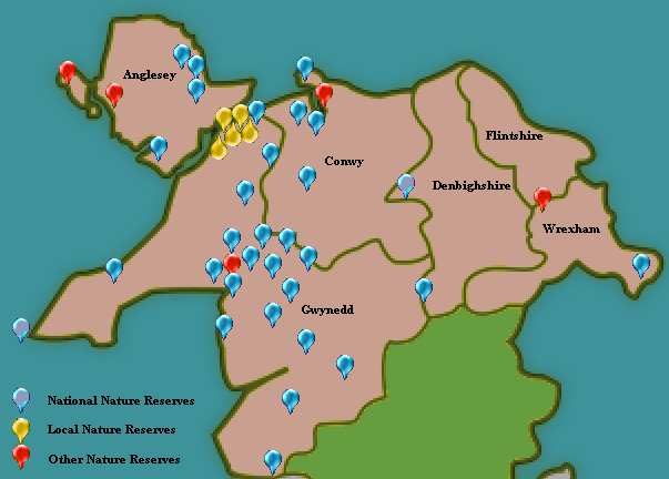
North Wales and its Nature Reserves
Wildlife, landscapes and ecology
The regional divisions of Wales used in this website follow those adopted by Natural Resources Wales (NRW), the organisation with key responsibility for the designation and management of our Areas of Outstanding National Beauty, Nature Reserves, National Parks and countryside in general.
To help you to locate nature reserves and other wildlife habitats, therefore, throughout this website 'North Wales' means the Isle of Anglesey together with Flintshire, Denbighshire, Conwy, Clwyd, Gwynedd and Wrexham.
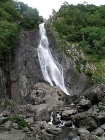
Below: One of the many lovely waterfalls in Snowdonia
North Wales is a beautiful area with some of the most dramatic scenery found in Wales. With such a diversity of countryside and wildlife habitats it is difficult to decide what might be the defining characteristic of the area as a whole.
For many of us North Wales is dominated by hills and mountains, including Snowdon, Wales’s highest mountain. But, apart from the Snowdonian mountains, to the North East lies the Clwydian Range of hills, forming a 35 kilometre chain of undulating landscape from the Vale of Clwyd in the west to the Dee Estuary in the east.
There is also the Berwyn Mountain Range, stretching from Llangollen in the east and along the Dee Valley to Bala in the west. Between these mountains and hills are valleys with rushing rivers and streams many of which are designated as SACs (Special Areas of Conservation) in their own right.
Add to this the fabulous coastline of North Wales with its vast stretches of sandy beaches, sand dune systems, fens, mosses (areas of lowland raised bogs), limestone pavement and woodlands and you begin to get an understanding of how important the Welsh landscape is to wildlife conservation. How lucky we are to have in a relatively small area, such an outstanding, globally important resource. All this is, by and large, completely free for us to visit and enjoy.
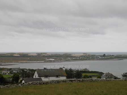
Below: A view across Morfa Dyffryn sand dunes
The Snowdonia Mountain Range and National Park
The Snowdonia mountains that we see today were largely shaped by the immense power of glacial activity during the last Ice Age, although the underlying structure of the range is much older and shows huge variation in its composition. The effects of the glaciers, both in their formation and subsequent retreat, contributed many of the features of Snowdonia with which we are so familiar today: the sharpened ridges and peaks, below which lie the amphitheatre-shaped cwms, (Cwm Idwal, Cwm Cywion and Cwm Melynllyn are examples). By the grinding action of the glaciers, the u-shaped river valleys and open plains of North Wales were forged from their original V-shaped structures.
In the 10,000 years since the most recent ice sheets retreated, Snowdonia has been gradually warming up and going through a number of defined climate changes. At first, only the hardiest plants of the arctic tundra could survive; but, as time passed, the mountains went through a Sub-Boreal Period (5000 to 2800 years ago) and then a Sub-Atlantic Period (2,800 years ago to the present), and many more trees, shrubs and plants grew and flourished there. This plant paradise did not last long: the very conditions that encouraged this growth also encouraged the presence of men, who soon set
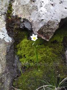
Below: Snowdon Lily - picture Mike McCabe, NRW
about clearing the forests and other vegetation in order to graze their animals and grow their cereal crops. As a result of all this activity, some of the botanical richness of Snowdonia is now limited to areas that were (and thankfully, still are) inaccessible to men and their farm animals.
Despite these changes, Snowdonia remains a place of outstanding natural beauty and conservation interest. Some of the land has been protected as European Special Areas of Conservation, while both Llyn Tegid and Cwm Idwal are recognized as internationally important wetlands under the Ramsar Convention. In addition, there are numerous Sites of Special Scientific Interest and around 30 National Nature Reserves in North Wales.
Clwydian Mountain Range
In 1985 the Clwydian Range was designated as one of the four Areas of Outstanding Natural Beauty that lie wholly within Wales. Not only is this 35 kilometre chain of hills of great geological and ecological interest, but there is also a wealth of archaeological and historic remains dating from the prehistoric times through to the Second World War, adding interest to any visit.
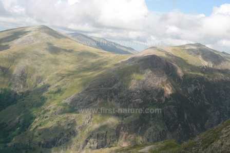
Below: The Snowdonia mountains
Probably most famous for its open heather moorland, the Clwydian Range also has impressive limestone outcrops with attractive woodlands and, lower down, grassland areas rich in orchids and other wildflowers. The area's two main rivers are the Alyn and the Wheeler, which in places disappear below ground into watercourses deep inside the limestone. Running along the crest of the hills is part of the Offa’s Dyke National Trail, and in addition North Wales Wildlife Trust has several nature reserves in the area.
The well-known country park of Loggerheads offers excellent facilities for visitors to the area.
The Berwyn Mountain Range
Less well known than the mountains of Snowdonia, the Berwyn range stretches from Llangollen in the east and beside the Dee Valley to Bala in the west. The
Below: A late summer day in the Berwyns
highest peak in the range is Cadair Berwyn, at 830 metres, but within the range there are no fewer than 24 peaks higher than 600 metres. The Berwyns seem to be best known for reports of a UFO crash landing in 1974, although the events of the night in question now seem to be generally attributed to a combined meteorite shower and earthquake. UFO landing or not, the Berwyns undoubtedly provide a haven for wildlife. The Berwyn National Nature Reserve boasts a vast areas of high moorland, which covers nearly 8,000 of the 24,000 hectares of the Berwyn range.
The Coast
North Wales is also well known for its lovely coastline and beaches, stretching from the Dee Estuary in Flintshire in the north to the Dyfi Estuary just south of Machynlleth in the west. On this coastal stretch are found Great Orme and Little Orme at Llandudno, the Lleyn Peninsula, Bardsey Island/Ynys Enlli, and the northern half of Cardigan Bay all of which have huge ecological diversity and are of great interest to naturalists. Anglesey is also renowned for its beautiful coastline and beaches. Many of the nature reserves have direct access to estuaries and other coastal habitats, with information boards and other facilities making it easy to find and enjoy the wonderful diversity of coastal wildlife.
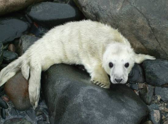
Below: A Grey Seal pup
Some of the most interesting habitats are in the sand dune systems and, in particular, the shifting dune systems at Morfa Dyffryn and Morfa Harlech situated between Harlech and Barmouth. Unlike other so-called ‘stable’ dune systems along the coast of Wales, these shifting dunes are still in a very active state of development, making this a rare and precious refuge for many kinds of plants and animals that need this strange environment. Once dune systems become stabilised, either as a result of Man's efforts to prevent the process of erosion, or because the source of sand swept in from the sea becomes exhausted, the dune habitats are degraded, soon becoming colonised by trees and shrubs that crowd out the special plants and other wildlife that depend upon active systems for their survival.
The Meironydd Oakwoods
These woodlands are remnants of the Atlantic Oakwoods that once covered much of the coasts of Europe, extending down from the coast of Northern Scotland around as far as Portugal. They are the home of many rare and endangered species of ferns, mosses, liverworts, lichens and fungi, which have been present there since the end of the last Ice Age. The woodlands are an ideal habitat for birds, insect,s and mammals - particularly bats. The woodlands in the Vale of Ffestiniog, and from Porthmadog down to Maentwrog, form the Meironydd Oak Woods and Bat Sites SAC. There are a number of nature reserves throughout the area, although not all are suitable for public access due to the dangerous nature of their terrain.
It is in part due to the inaccessibility of some of these woodlands, which are mainly situated in steep, rocky river gorges, that some remain in almost pristine condition. Even those sites that have been damaged over the years by conversion to agricultural or forestry land, are well worth restoration, because the seeds of flowering plants and trees that have remained within the soil can still germinate and grow even after many years of lying dormant. There are a number of restoration and management programmes being run throughout the woodlands.
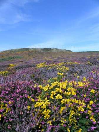
Below: Heather and gorse light up the cliffs at South Stack on Anglesey
Isle of Anglesey
Anglesey (Ynys Môn, in Welsh) is situated off the north-west coast of Wales, separated from the mainland by the Menai Strait. During the Middle Ages, Anglesey was also known as Mam Cymru (Mother of Wales) because its fertile land produced much of the food consumed in the northern part of Wales.
The entire island of Anglesey is designated as an Area of Outstanding Natural Beauty. (It is the largest AONB in Wales.) Anybody who has spent time there and visited some of the exceptionally beautiful coastal areas will readily appreciate the reason for this designation. But, as you will see from wealth of the nature reserves throughout Anglesey, there is a lot more than just the lovely coastline to enjoy during a visit to the island.
Wales, particularly North Wales, is almost as famous for its rain as it is for its scenic beauty. Anglesey has its own micro-climate, resulting from its separation by the Menai Strait and Snowdonia mountains from the rest of North Wales. Consequently, rainy conditions in Snowdonia's Capel Curig, for instance, does not necessarily imply that it will also be raining in Anglesey, even though it is only a few miles away. So, if your hike to the top of Snowdon is rained off, why not head for Anglesey where the sun could well be shining?
The Anglesey Coastal Path
This existing 125-mile (200 kilometre) path will, from 2012 onwards, form part of the all-Wales Coastal Path. The Anglesey Coastal Path circumnavigates the island, passing through breathtaking and diverse scenery that includes extensive sand dune systems, rocky coves and heather-clad cliff tops. Officially, the path starts and ends at St. Cybi’s Church in the port town of Holyhead, although it is of course possible to pick up the path from any number of places. Several circularshort walks incorporate part of the coastal path, and access to the path can be gained through some of the nature reserves situated close to the coast, including Newborough Warren and Cemaes Bay. At Llangoed one of the delightful Afon Lleiniog Woodland Footpaths links to the Coastal Path at Lleiniog beach.
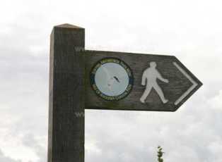
Below: The Anglesey Coast Path sign
The highest point on the Coastal Path is at Holyhead Mountain, some 200 metres (720 feet) above sea level. For the most part, however, this is a lowland walk and can be completed comfortably in 12 days of unhurried walking. The route primarily caters for walkers, but there are parts that can be traversed by bike or on horseback, and some sections are suitable for prams and for wheelchair users.
The Path passes through many different habitats, providing opportunities to see and enjoy a huge variety of wildlife. The sand dunes and cliff tops are home to numerous wildflowers, including a large number of wild orchids.
The Anglesey Fens
After East Anglia, Wales has the second largest expanse of fens to be found in the UK, and on Anglesey there are three National Nature Reserves (NNRs) which cover large areas of fenland: Cors Erddreiniog (the largest of the three), Cors Bodeilio and Cors Goch. These NNRs protect a rare type of wetland, fed by alkaline water that drains into the fens from the porous limestone rocks that surround them. When wetland habitats are on peaty soil over sandstone, granite or other chalk-deficient substrates they are normally acidic in their composition. It is the alkaline water draining into these wetlands in Anglesey that creates the unique conditions that support an unusual combination of plants, many of which can only exist in this type of alkaline habitat. The plants in turn harbour many species of insects, in particular, which have become rare elsewhere in the UK.
Below: Red Squirrels are increasing in numbers on Anglesey
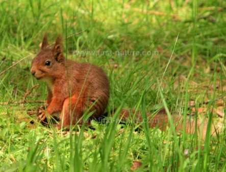
Red Squirrels in Anglesey
Since 2003 a programme has been running in Anglesey to reintroduce the red squirrel (Sciurus vulgaris), which was once widespread throughout the island. It seems that the red squirrel population declined sharply during the 1980s, and by 1998 red squirrels had probably become extinct at Newborough Forest, one of its former strongholds. At the same time as repopulating the forest at Newborough, there has been an aggressive trapping regime to remove grey squirrels from the area. By 2000 the red squirrel population had doubled, and by 2002 the population had reached the carrying capacity of the forest. During the same period there were reports of red squirrels foraging within the broadleaved woodlands adjacent to Newborough, and this outward migration seems to be continuing.
The project, funded and managed by Menter Môn (the Anglesey Enterprise Board), seems to have been very successful. There are reports that red squirrels are now spreading throughout woodlands on the island and even turning up on bird feeders in gardens.
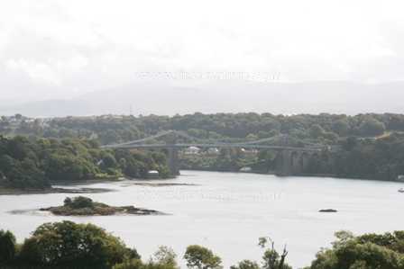
The Menai Strait
The Menai Strait separates Anglesey from the mainland of North Wales. This narrow stretch of water, some 20 kilometres in length, supports over 1,000 species of wildlife on its shores and in its waters. The geology of the Menai Strait is interesting, because it is sited on a fault zone dividing the mainland of North Wales and the Snowdonia Mountains from the older rocks of Anglesey. This geological fissure, which was flooded as sea levels began to rise some 10,000 years ago, was deepened during the last Ice Age by the grinding action of glaciers. The resulting marine environment of the Strait created by these physical forces is unique in Great Britain. In some parts, strong currents swirl over the bedrock and boulders; in others the water flows sufficiently slowly to allow thick layers of sand and mud to settle. It is this diversity of habitats that enables such a wealth of wildlife to thrive there.
Below: The area of the Menai Strait referred to as The Swellies
Known as the Swellies, the narrow section of water between the two bridges is a tidal rapid with extremely dangerous currents. Despite this, it is home to marine creatures that thrive in such conditions. Sponges in particular are abundant there. Seaweeds dominate the rocky shores, while at either end of the Strait wide, sandy flats are home to a rich community of burrowing marine creatures. As a result, these soft, sandy areas attract large and diverse populations of birds. Waders in particular feed and roost there.
The seabed in the deeper parts of the Strait is dominated by colourful marine animals, but few plants grow there because the murky water created by the currents deprives them of the light necessary for them to feed and grow.
There are proposals to make the Menai Strait, including the waters, shores and seabed, into the second Marine Nature Reserve in Wales (the first being off the coast of Skomer). The shore of Nant Porth Nature Reserve would form part of this reserve, which would stretch from Malltraeth on the west coast of Anglesey as far as Red Wharf Bay on the east coast.